Urban Climate Analysis in R
LCZ4r is a comprehensive R package for analyzing and visualizing Local Climate Zones (LCZ) and Urban Heat Islands (UHI).
From Data to Insight
LCZ4r simplifies the entire workflow of urban climate analysis. It provides a suite of tools to download, process, visualize, and interpret LCZ and UHI data, making complex spatial analysis accessible to researchers, urban planners, and climate scientists.
Get StartedA Complete Toolkit for Urban Climate Research
Explore the key functionalities that make LCZ4r a powerful tool for urban climate studies.
Global Data Access
Download Local Climate Zone maps from global, European, and USA datasets, or bring your own data from the LCZ Generator.

Advanced Visualization
Create publication-quality maps of LCZ classifications, thermal anomalies, and interpolated temperature surfaces.

In-depth Analysis
Calculate LCZ area distributions, analyze time series data, and quantify Urban Heat Island intensity with specialized functions.

QGIS Integration
Seamlessly integrate LCZ4r with QGIS for a powerful and user-friendly geospatial analysis experience.
All Functions
| Function | Description |
|---|---|
lcz_get_map()
|
Download LCZ maps from the global dataset |
lcz_get_map_euro()
|
Download LCZ maps from the European dataset |
lcz_get_map_usa()
|
Download LCZ maps from the USA dataset |
lcz_get_map_generator()
|
Download LCZ maps from the LCZ Generator Platform |
lcz_plot_map()
|
Visualize LCZ maps |
lcz_plot_parameters()
|
Visualize LCZ parameter maps |
lcz_cal_area()
|
Calculate the area of LCZ classes |
lcz_get_parameters()
|
Retrieve LCZ parameters |
lcz_ts()
|
Analyze LCZ time series |
lcz_anomaly()
|
Calculate LCZ thermal anomalies |
lcz_anomaly_map()
|
Map LCZ thermal anomalies |
lcz_interp_map()
|
Map LCZ interpolation results |
lcz_interp_eval()
|
Evaluate LCZ interpolation accuracy |
lcz_uhi_intensity()
|
Assess Urban Heat Island intensity |
Geospatial Analysis, Simplified
The LCZ4r-QGIS plugin brings the power of LCZ4r directly into your QGIS environment.
Compatible with QGIS 3.x and above. Integrates directly with the LCZ4r R package.
Learn more about the Plugin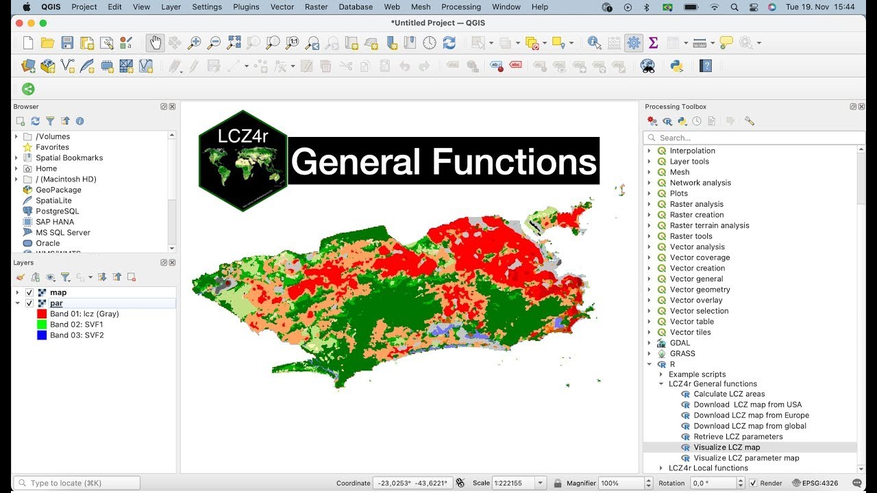
Interactive Urban Climate Platform
This platform was developed specifically for Geography students and researchers interested in understanding urban climate phenomena.

Published in Nature
LCZ4r package R for local climate zones and urban heat islands
The methodologies and applications of the LCZ4r package are detailed in our peer-reviewed publication in Nature Scientific Reports.
Read the Paper
Meet the Developers
LCZ4r is developed and maintained by a dedicated team of researchers and scientists.


Supported By
The development of LCZ4r is made possible through the generous support of the following organizations:
Ready to get started?
Explore the package, contribute on GitHub, or get in touch with the team.